This is why it’s not always a good idea to cycle when there’s a severe weather warning.
6 comments
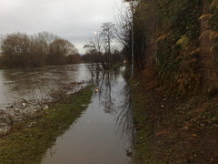
Lawks! Whereabouts is that?
That’s the River Aire in Leeds, just behind the student halls at Clarence Dock. If you click through the picture to the Flickr page there’s a map there.
And map of the bike route at http://sportstracker.nokia.com/nts/workoutdetail/index.do?id=1843747. I originally planned to cycle along the canal from Horsforth where I live through to Woodlesford and back along the roads, but flooded and closed towpaths meant there was a lot more road than I originally planned.
And map of the bike route at http://sportstracker.nokia.com/nts/workoutdetail/index.do?id=1843747. I originally planned to cycle along the canal from Horsforth where I live through to Woodlesford and back along the roads, but flooded and closed towpaths meant there was a lot more road than I originally planned.
That’s the River Aire in Leeds, just behind the student halls at Clarence Dock. If you click through the picture to the Flickr page there’s a map there.
Lawks! Whereabouts is that?